Iatlantic Logo Hybrid
  • Our Work
    • Work Packages
    • Study areas
    • Expeditions
    • Science to policy
    • Innovation & Exploitation
    • Deliverables
    • Publications
    • iAtlantic GeoNode
    • iMirabilis2 Expedition
  • Our Team
    • Consortium
    • Steering Committee
    • iAtlantic Fellows
    • Advisory Board
    • Science Council
  • News
  • Events
    • Webinar archive
    • iAtlantic GA 2023
    • iAtlantic Annual Meetings
    • iAtlantic Workshops
    • iMirabilis2 Expedition
  • Resources
  • Contact
Menu
  • Our Work
    • Work Packages
    • Study areas
    • Expeditions
    • Science to policy
    • Innovation & Exploitation
    • Deliverables
    • Publications
    • iAtlantic GeoNode
    • iMirabilis2 Expedition
  • Our Team
    • Consortium
    • Steering Committee
    • iAtlantic Fellows
    • Advisory Board
    • Science Council
  • News
  • Events
    • Webinar archive
    • iAtlantic GA 2023
    • iAtlantic Annual Meetings
    • iAtlantic Workshops
    • iMirabilis2 Expedition
  • Resources
  • Contact
Login
Search
Close this search box.

Using artificial intelligence to help explore the deep Atlantic

  • 7 October 2020
  • Back

On 10 October 2020, a team of 12 young scientists will set sail from Emden, Germany, on the RV Maria S. Merian to explore the diversity of the deep seafloor in the NE Atlantic. But this is no ordinary survey mission: the team on board will be combining traditional scientific data collection with state-of-the-art machine learning techniques to broaden our understanding of what the seafloor looks like and what geochemical processes are at work in different deep-sea environments. This will provide valuable information and new methodologies essential for iAtlantic’s basin-scale assessment of Atlantic ecosystems.

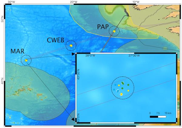
The METAL-ML expedition team is heading for the Porcupine Abyssal Plain, south-west of Ireland, where they will start an ambitious seafloor survey and sampling programme. Their journey will then take them south-westwards to the Central Western European Basin and then over to the Mid-Atlantic Ridge (see map, below). Along the way, they will explore the many different terrains of the deep seafloor – parts of the ocean that were traditionally thought of as flat, muddy plains. Although our knowledge of these areas is now more advanced, only about 20% of the ocean floor has been surveyed with echosounder and considerably less has been subject to detailed geochemical sampling, meaning that our knowledge of the ocean floor and its processes is still somewhat limited.

METAL-ML map
Route of the MetalML expedition, showing the three main working areas in the Porcupine Abyssal Plain (PAP), Central Western European Basin (CWEB) and the Mid-Atlantic Ridge (MAR). marked by black circles and local working areas marked by dots along the profile (see inset map for details). Positions of local working areas are schematic. Blue dots correspond to hills, green dots to plains and yellow dots to valleys.

“All we have are basically pinpricks into the giant cloak of the unknown that is covering the seabed”, explains expedition leader Dr Timm Schoening from GEOMAR Helmholtz Centre for Ocean Research Kiel. “We already know that deep-sea plateaus aren’t all flat. There are sinks, hills, many different landscapes. It is likely that the composition and appearance between a hill and a sink will differ, and with that the geochemical processes taking place there. This probably affects the local animals and microorganisms. But these differences and the effects they are having are exactly where we still lack information”.

It would be impossible for the team to map and sample the whole North Atlantic during their four weeks at sea, but this is where the innovative approach comes in, using multi-stage measurements and sophisticated machine learning techniques. Between Ireland and the Mid-Atlantic Ridge, the RV MERIAN’s multibeam echosounder will map the seafloor at a regional (km) scale. A towed camera system will take photos at selected locations to provide a view of the seafloor at the metre scale, and those images will later be aggregated to form high-resolution maps. At specific sampling points, a TV-multi-corer will be used to take multiple samples from the upper sediment layers of the seafloor, providing a detailed (cm-scale) view of the geochemical processes at work in different seafloor environments.

“With the help of new data analysis methods, we want to scale up the results of our samples onto the local photographic maps” explains Dr Schoening. “The results of these mosaic maps on the other hand will be extrapolated to the echo sounder maps with the help of machine learning”.

Sophisticated machine learning techniques will be used to extract meaningful information from the different data sources and scale-up detailed observations to broaden our understanding of the seafloor at much larger scales. Automated image analysis will extract information about seafloor characteristics from the photographs, and then link those with the geochemical sample information – meaning that cm-scale measurements can be scaled up to give a broader picture of local substrates and habitats. At the next scale up, camera observations will be linked to the seafloor mapping data from the echosounder, making the jump from metre-scale photographs to regional maps.

But the benefits of this expedition are about more than just exploring the ocean. As Dr Schoening observes “This expedition is a great opportunity to improve the collaboration between data scientists and geochemists – both disciplines are represented in our team and we often notice how different the structures in our thoughts and work can be. A joint expedition offers the opportunity to explore synergies between both disciplines and test them in the field”.

You can follow the progress of the METAL-ML expedition via their blog at www.oceanblogs.org/msm96.

The data collected on expedition MSM96 contribute to the  iAtlantic project and the research group Bathymetry of the DAM (German Alliance of Ocean Research). Furthermore, they will be used for the GEBCO Seabed-2030 project, which aims to have all seafloor measured via echosounder by 2030. Expedition scientists are from GEOMAR and Jacobs University Bremen.

PrevPreviousEMSO-Azores celebrates its 10th birthday…in a unique way!
NextInnovation on the seabedNext

Share this

iAtlantic_logo
  • Our Work
  • Our Team
  • News
  • Events
  • Resources
  • Contact
  • Our Work
  • Our Team
  • News
  • Events
  • Resources
  • Contact
Facebook-fXlogoInstagram

© 2024 iAtlantic. All rights reserved.

EU

This project received funding from the European Union’s Horizon 2020 research and innovation programme under grant agreement No 818123 (iAtlantic). This output reflects only the author’s view and the European Union cannot be held responsible for any use that may be  made of the information contained therein.