Processing seafloor imagery with FAIR image Digital Objects (iFDOs)
What are iFDOs?
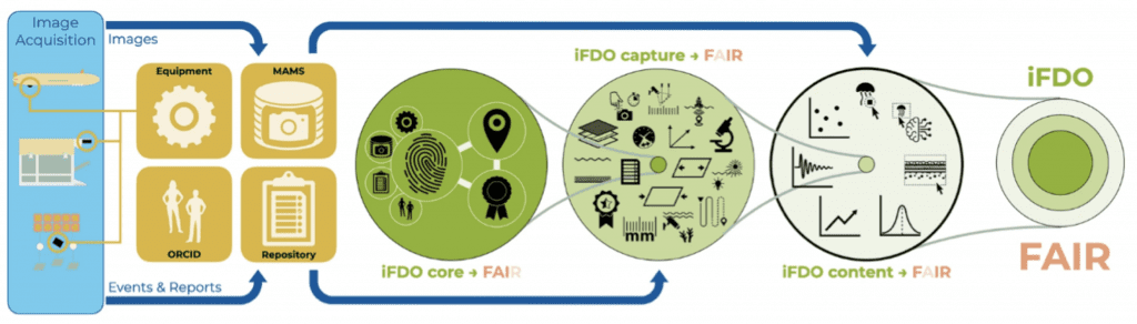
The team at GEOMAR and NOC is working on making marine image data FAIR (Findable, Accessible, Interoperable, and Reusable) using image FAIR Digital Objects (iFDOs). They provide a standardised framework for processing marine imagery. The team further presents an infrastructure environment to create, validate, manage, and store these iFDOs, and which data associated with imagery should be curated (see figure below).
Setup of image FAIR Digital Objects. Key information and image data is stored in a dedicated infrastructure (yellow squares). iFDOs only contain persistent identifiers to those external information resources. Additionally, specific metadata for marine imaging use-cases is stored inside the iFDO files. iFDOs consist of three sections: (1) the required core part which includes the persistent identifiers as well as licensing information; (2) the recommended capture part that addresses the technical heterogeneity of image acquisition; and the (3) the optional content part that captures semantic information from within the images to address the heterogeneous nature of image data. Together, these three sections constitute one iFDO file. This file contains header information on the entire image data set as well as detailed information on each image item within a defined set of images (Schoening et al. 2022: https://doi.org/10.1038/s41597-022-01491-3).
What can be achieved by using iFDOs?
The goal is to reduce image management overheads while simultaneously creating visibility for image acquisition and publication efforts. Ultimately, the curated image data are the key to efficient and effective Artificial Intelligence (AI) applications that detect and classify objects within well-curated image data sets.
Why are iFDOs important?
Underwater images are used to explore and monitor ocean habitats, generating huge datasets with unusual data characteristics that preclude traditional data management strategies. Due to the lack of universally adopted (meta)data standards, image data collected from the marine environment are increasing in heterogeneity, thus preventing objective comparison. Hence, the extraction of actionable information remains challenging, particularly for researchers not directly involved with the image data collection. Standardised formats and procedures following the FAIR principles, such as the iFDOs, are needed to enable sustainable image analysis and processing tools, as are solutions for image publication in long-term repositories to ascertain reuse of data.
For more information
If you want more info, do not hesitate to contact Timm Schoening (tschoening[at]geomar.de), but please also check the following:
Main contributors: Timm Schoening, Jennifer Durden, Henk-Jan Hoving, based at the GEOMAR Helmholtz Centre for Ocean Research (Germany) and the National Oceanography Centre (UK)