The iAtlantic BR10-Petrobras cruise was affected by the sad damage of the towed camera system. Still, we were able to perform one 2-hour long video profile with a good view of the sedimentary bottom of the Santos Basin slope area and some carbonate outcrops near the rim of the pockmarks. Lots of fish and shrimps were observed, indicating the area may be a productivity hotspot in the slope regions off Brazil.
We compensated for the camera system loss by increasing our seafloor mapping coverage with the unexpectedly very high resolution multibeam echosounder system (MBES) of RV Vital de Oliveira (~24 m). These efforts covered all of the shelf break/upper slope area and allowed us to see quite interesting unknown geological features that are worth exploring (see below). These included some very large (~2km) ridges which we speculated could be authigenic carbonate features. Also, there were much smaller linear ridges in between pockmarks which we sampled with the box corer and revealed they were covered with scleractinian coral rubble, suggesting they could be coral mounts. In one box corer we sampled a live black coral colony, which confirmed that there are corals sitting on top of these mounds.
The MBES also revealed many of what we believe are trawl fishing tracks. We plotted them against deep-sea trawl fishing records (for the period 2000 – 2008) and some of them matched perfectly, showing that they could be at least 17 years old. Quite amazing!
Thanks to the data acquisition capabilities of the RV Vital de Oliveira and the hard work of the crew we ended up with an extensive set of environmental data which will allow us to demonstrate how interesting and important this area of the Atlantic is. And of course, to provide strong justification for more cruises to this area in the future.

In the final part of our cruise (14-19 December 2022) we started a box core sampling strategy on the pockmark field in order to describe seafloor textures, check for the presence of cold-water corals and characterise macro- and meiofauna diversity. We performed, in total, 35 deployments in water depths of 400 – 1000 metres. We aimed at regions surrounding the rims of pockmarks and found that sedimented seafloor was always dominant, usually with a 5-6 cm of organic matter on the surface. We also sampled over geological features that looked like linear crests formed in between pockmarks and finally found abundant coral rubble that suggested that these could be coral mounds. At last, on one of these features (16 December), we captured a live black coral colony that supported this theory and made us very happy. It was a good reward after hours of mud sieving, conducted around the clock for three days by two enthusiastic teams of very young scientists.

We finished our sampling activities on 19 December, after completing the sediment sampling procedure for on board experiments and completing high resolution bathymetry mapping of the entire study area. We set sail to Rio de Janeiro and spent the time in transit organising samples and data. We had massive support from our Navy friends who processed long hours of MBES, CTD and current speed data (L-ADCP) just in time for us to pack up. We are greatly indebted to them. And we also celebrated the “Saylor’s Day” (13 December) with “churrasco & samba” on board. On our last night there was a seminar, which gave us a chance to present the iAtlantic and Petrobras activities and discuss the progresses made during this cruise.
13 December 2022
In the past two days (11-12 December) we have concentrated our efforts on mapping the entire slope region and its vast pockmark field. We came across large geological features that rise to the seafloor surface, possibly made of carbonate rock carved over millennia by the Brazil Current. These features may provide hard substrate for benthic fauna amidst the extensive muddy seafloor. Unfortunately, we can only guess about what lives on them, since our tow cam is still inoperable.
Our mapping continues now over shallower areas (300 – 500 m) of the shelf break. We are also starting a CTD transect across the slope area to determine the distribution of the deep water masses of the SW Atlantic and their potential influence on benthic habitats. With that we try to make the best possible description of the physical environment, as our capacity to sample the associated biota has become limited.
On the horizon we watch the Itajaí oil platform, which reminds us of the essential services provided by the deep sea and how important is the environmental work we try to accomplish on board the RV Vital de Oliveira.

Sunday 11 December 2023
We set sail from Santos Harbour on Tuesday afternoon (Dec 6). The tow cam winch installation required more time than expected, and we all wanted to make sure the system was fully functional and running as safely as possible before we left to our mission.
On Wednesday 7 Dec, we headed towards our deepest study area (1000 m) to collect box core sediment samples. These samples will feed experiments in the ship’s wet lab set up by Dany Yepes and her team from UFES, as part of iAtlantic’s work on cumulative stresssors.
But before that we made a stop at a 250 m deep station to perform a tow cam test. This was essential to get us all familiarised with the camera operation before we reach the target exploration area in Santos Basin upper slope (300 – 800 m water depth).
Box core sampling was conducted at night, preceded by CTD casts to record water column conditions and collect deep-sea water to run the experiments in the lab.
The next day (Thursday 8 Dec) we proceeded with seafloor mapping using multibeam ecosounder, at water depths between 800 and 700 m. We identified pockmarks and other features of interest, and made plans for tow cam profiles.
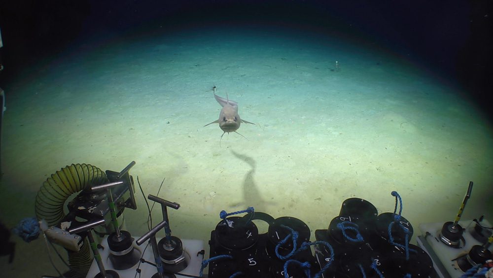
On Friday (9 Dec) we started our first tow cam deployment very early in the morning, and conducted a 2-hour ‘flight’ over a very interesting sedimented pockmark area with abundant fish and shrimp species. We also observed some hard bottom at the rim of the pockmark with anemones, black corals and sponges.
Unfortunately we have since encountered some technical problems with the camera system and we are trying hard to fix it with the great help of the dedicated crew of RV Vital de Oliveira. Meanwhile, we carry on mapping the area and describing very interesting previously unknown geological features which we hope we will be able to explore later on with the tow cam. Fingers crossed!


Blog entry by Lisa Skein & Luis Greiffenhagen
The last scientific work finished around 20:00 when the Continuous Plankton Recorder (CPR) came back on deck, and that’s the end of scientific operations for JC237! In today’s science meeting, we had summary presentations from all the scientific disciplines including bathymetric mapping, oceanography, sedimentology, geology and biology. These presentations were great as a recap of all that has been accomplished in the past five weeks, and myself (and I think everyone) was once again blown away by the incredible amount of precious deep-sea data that’s been collected. This work will help to shed light on the inner workings of submarine canyons and abyssal plains, and will also enable us to better protect and manage habitats like these in the future. In addition to all the hard work, it has also been great to have the opportunity to make new friends from across the world. After quite literally being ‘in the same boat’ for five weeks, you do start to feel like a little seagoing family!
After these presentations, we headed for dinner (the last curry night of the cruise, sadly), after which we had some good chats in the lounge. We are currently on our way back to Southampton and I think everyone is quite excited to see land for the first time in a month!
This cruise would not have been what it was without an amazing PI, Veerle Huvenne (NOC). Thank you Veerle for ensuring that we had a great working environment, for all the organising, and for everything else going on behind the scenes that we didn’t know about! It’s been an honour sailing with you. A big thank you also to Captain John Leask, officers and crew of the RRS James Cook. None of this would have been possible without your hard work, and hopefully we’ll sail together again soon!

…and wrapping up operations!
Blog entry by Luis Skein & Luis Greiffenhagen
If you have ever wondered what life looks like on a research vessel, then this blog article is for you! Luis and I have both joined the JC237 expedition as volunteer early-career researchers. Neither of us had been on a cruise like this before, and so neither of us really knew what to expect. We had no idea of how the cabins would be, the food, the people, the work schedule, and everything else. Looking back now at the end of the cruise, I think it’s safe to say that our concerns were completely trivial. On a research expedition, it’s important to capitalise on all the ship time you have available. As a working vessel, all on board work in shifts around the clock, which means there is always someone on duty. Some operations, ROV dives in particular, can take around 14 hours or more to complete. This means that operations span consecutive shifts, and you’ll often only briefly see the other shift team as your own shift is coming to an end and theirs are starting, or vice versa.
As I was on the night shift team (16:00 – 04:00) and Luis on the day shift team (04:00 – 16:00), our days on board looked slightly different. We thought it would be a good idea to give a little insight into what each of our days looked like in the past month.
Part I – The night shift (Lisa)
13:00: Rise and shine!
I’ve tried to get up around 13:00 each day. Once awake, I’d go to the gym (yes, there is a gym on board complete with treadmill, rowing machine, weights, and even a sauna!).
15:00: Coffee and catching up
Following exercise and shower, I’d dash up to the galley to grab a coffee and some fruit. I tried to make a point of going to sit outside in the sun before the shift started. You’d often find some other night shift team members doing the same by the time you get outside! When my internet connection allowed, I’d try to catch up with those back home.
16:00: Science meeting
We have a daily science meeting at the same time every day. This is when the entire team would get together and cruise PI Veerle Huvenne (NOC) would bring everybody up to speed with what has happened in the past 24 hours, and run through the plan for the next 24 hours. Following the meeting we’d immediately get to work. This can mean finalising tasks that the day shift was busy with, for example to finish processing push cores brought up by the ROV earlier the morning.
17:30: Dinner time!
Being on shift doesn’t mean that you don’t have time to eat! Dinner time is generally attended by both shift teams, so it also gives us a chance to catch up with each other and (try) to have conversations about things other than science!

18:00 – 04:00: Continuing work
On most ROV dive days, the Isis ROV would be launched shortly after dinner, and from then on we’d take turns to be in the ROV van with the pilots. At the same time we may also be processing mega-core samples from the seabed – a muddy business! I found it really nice to be able to alternate between being quite stationary in the ROV van, and doing more physical work such as mega-core processing.
04:00: Time to relax
As the day shift comes in the lab, we’d sometimes head up to the lounge for a game of darts, cards, or a just a good chat before heading to bed.
Part II – The day shift (Luis)
3:45am:
Bright and early, I rise. Gareth and I will make sure neither of us has missed their alarm and then we head up to the science lab. Usually, we would get a quick introduction from James, the lead scientist of the night shift on what happened on the ROV dive so far, which waypoints and missions are still planned before the ROV goes up.
I would get a quick coffee and then head into the ROV van with Josh and Brian, while Tim is usually busy processing all the new bathymetry data from the day before. In the ROV van, we continue to pick up samples, sediment cores and do video transects. If it’s not super busy, some of us can sneak out to watch the sunrise with Michael, our pigeon.

When we reached the last waypoint, normally Veerle comes in and decides if we still have time to add some time to explore (depending on the schedule of the day). This can be just an unknown cliff on the map close by or going up a ridge a bit further. Between 07:30 and 08:00 we all get a quick, delicious breakfast. After 12-14hrs, the ROV leaves the seafloor and begins the ascent. Depending on the depth, hours of blue water on the screen follow. At the same time, we have to copy and transfer all the video files and make sure everything has been logged correctly. Going up the last hundred meters can be filled with surprises, as we reach the territory of shark etc. (see previous blogs).
As soon as the ROV comes up, we get on our PPE (personal protective equipment) and head out onto the deck. There will be lots of biological samples, water samples and push cores to process, which will keep us busy for the rest of the shift. I will usually process the cores, and, as they all go to different people with different research questions, we have to be careful which person the core is for. Some are for organic carbon analyses, some for eDNA, others for microplastics analyses. Depending on which, we may have to wear different work clothes and use different tools. The processed samples will then be taken to a freezer. While we do that, the AUV will be recovered or go on another mission. In between we fit a great lunch.


In the afternoon, after we finish our shift, I usually try to go to the gym and cycle a bit before dinner, as I heard that it is quite easy to put on weight, when you are on a ship for weeks… After dinner, I head up to the aft deck and relax a bit, look at the ocean, watch seabirds and the ROV go in again.
If I don’t want to be super tired on the next day, I then have to go to bed around 8pm and that’s it!


Interview by Luis Greiffenhagen
We heard a lot about the ROV dives and its missions. But all of this is only possible thanks to the ROV team of NOC that is engineering and piloting ROV ISIS. You might ask yourself what it is like to be piloting a vehicle thousands of meters below the surface. ROV pilot Martin Yeomans kindly answered a few questions for us…

How did you become an ROV pilot?
For me, I studied mechanical engineering at Portsmouth university and spent 4 years in industry, improving and learning more in the field. I then applied to be a ROV Pilot/Engineer at the NOC where most training is on the job and spans 2/3 years + though there is always more to learn and know, as the sector and technology is continuously improving and changing!
What do you love about your job?
The job is so diverse! You’re in the office one moment planning and designing, then in the hanger/workshop working on the vehicle, next thing you’re out on the ocean exploring the sea floor, seeing some incredible marine creatures and environments! The other enjoyable part is when you have the technical challenges to overcome to meet science objectives, the piloting of the vehicle and using the manipulators for any task that is required subsea!
When in the water, who of the team is doing what?
The team is split into two shift patterns plus a supervisor that covers a shift that overlaps both. During a dive, we rotate our positions between the pilot seat and co-pilot/engineers’ seat. The engineer will operate the manipulators and other hydraulics, control ships positioning to manage the umbilical and ROV subsea (This can all change depending on what the environment and currents are like), operating / adjusting the navigation and monitor all the systems to ensure they are operating correctly.
The pilot will fly the ROV to the specified way points and setup for sampling. They will assist the engineer by operating the cameras, adjusting them when needed. They are also the ones that have to operate the vehicle smoothly in challenging environments, being alert to any environmental changes in terrain such as overhanging cliffs, the current and visibility to name a few. All which can be extremely challenging!
What was the scariest / most difficult situation on this cruise’s dives?
Operating through the dynamic canyon environments with strong currents and poor visibility!
What was your favourite dive so far?
There was a dive where we were sampling and a ray decided to come along and pay us a visit as well as getting a view of a blue shark during the recovery.
What kind of work happens before/after the cruises?
There are many jobs that need doing though in to summarise for pre-dive it will be any configuration changes depending on the mission objectives, system checks and setting up the data bases/logs.
Post-dive, we prepare the vehicle and make it safe for scientists to collect their samples, oil samples are taken to check for any contaminants and water ingress, fault finding and repairs if needed, all data is collated and host of other checks are done in readiness for the next pre-dive.
How do you like life on a ship?
Life on the ship is great! The commute to work is short… you get to meet so many interesting people from all over the globe with some great stories and the food is good too, its hard not to say no to the desserts!


The Porcupine Abyssal Plain
Blog entry by Luis Greiffenhagen
After spending around two weeks at Whittard Canyon, we travelled further west. After a 24h transit, we reached the Porcupine Abyssal Plain (PAP). It lies in international waters, southwest of Ireland and the Porcupine Seabight. The seafloor is almost four times deeper than most of our dives in Whittard Canyon, with an average depth of 4840 meters. The bottom is mainly flat, consisting of muddy sands, however, there are a few elevations, the so-called “abyssal hills”. Originating from mid-Atlantic tectonic activities millions of years ago, they can be up to 1000m tall.


PAP is uniquely important for deep sea research as a “fixed point observatory”. Together with one other place in the Pacific, it is the only deep-sea site in the world that has been continuously studied for more than 30 years. While scientists like to explore new places, constantly going back to the same place and creating long-term datasets is what helps us understand the processes of a changing ocean. Brian Bett (NOC) who is coordinating the missions at PAP on this cruise was one of the initiators of the PAP programme in the early 1990s, which started as a joint collaboration of German and British scientists. In situ biogeochemical data have been measured ever since, are open access to everyone, and can be explored here alongside other information. PAP is an incredible opportunity to investigate the impacts of climate change on the open ocean and the deep sea. Therefore, our visit to PAP runs under the framework of the CLASS (Climate Linked Atlantic Sector Science) programme.
In our time at PAP, we deployed a CTD (conductivity, temperature, density), took DNA water samples and conducted video surveys with the ROV. This is, excitingly, the first time an ROV has ever gone down to PAP. The dives are long, taking 3 hours just to descend and reach the bottom. This makes sense, considering that it’s the equal height to the Mont Blanc. Down there, we saw amazing creatures, very different to the Whittard Canyon. We had the unique opportunity to sample some species for DNA analyses and other taxonomic reasons. A highlight was a 50cm-long, purple deep-sea cucumber, and a coral that is possibly undescribed. While we were sampling, a group of rattail fishes (Grenadiers) was carefully observing our activities. Further, we still had time to climb one of the abyssal hills with the ROV. When we reached the summit, it felt like a mountaineer, being the first person in the world on this peak.


Last, but not least: as a little funny experiment we all got our personal styrofoam cups – and sent them down to the abyss with the ROV. When our cups came back up, they were much smaller from the immense pressure (more than 400 bar) and oddly deformed. What a souvenir! And even more incredible to think that all the little, fragile looking animals of PAP can withstand that pressure.


Blog entry by Lisa Skein
Going to sea for long periods of time gives one the chance to meet many new people that you most likely would not have met otherwise. This also brings the opportunity to hear many different stories from people who have sailed all over the world. I’ve been particularly interested in hearing some stories from the officers on the bridge and, as it appears, so too have some scientists and technicians. So this Friday evening, I gathered a few questions from the main lab to take upstairs!
On duty on the bridge this evening with Chief Officer Ian McLeod and Third Officer Jordan Greenhow. For both officers, life at sea has delivered many extraordinary experiences and I had a great time listening to what is probably only a very small snippet of a seagoing life. Below are a few questions I asked the officers on duty and their responses. Enjoy!
Let’s start with the basics. Where are you from?
Ian McLeod: Western Isles, Scotland.
Jordan Greenhow: Cambridge, England.
How long have you been going to sea for?
IM: 18 years.
JG: 10 years.
What is your favourite part about going to sea?
IM: A nice aspect is that it’s a job with time-on and time-off schedules. It’s great to be at sea say for eight weeks, and then knowing that you’ll have around eight weeks off once you’re back. It makes for a good work-life balance. Plus it’s a lot of fun to work on research vessels as the work is very interesting and you get to learn a lot!
JG: I’ve also really enjoyed working on research vessels for the past five years. Before this, I have worked on offshore vessels, ferries, hospital ships, you name it. But the things you get to do and places you get to go on research vessels is great. Going on research expeditions, especially to very remote regions in the world, gives you the chance to see things that not many other people will ever get to see.
What is the longest time you’ve spent at sea?
IM: My longest continuous trip at sea was for six and a half months when I was doing training on a Norwegian cargo ship. It was a fairly standard cargo ship transporting goods like timber and metals. The ship used to sail from Chile, over to Taiwan, up the Chinese coast, to Los Angeles, and back again to Chile. It was okay as I knew this was needed to complete my training, although I’m not sure if I’d be very keen on doing that again!
JG: In 2019, I set off on what was meant to be two-month trip to Antarctica. As the Covid-19 pandemic unfolded, the trip was extended bit by bit in what ended up being four and a half months in the end. It was great to have had a trip down to Antarctica, but it wasn’t great not knowing when you’d finally be able to go home. In the end, we refuelled at the Falkland Islands and ended up sailing the ship all the way back to the UK (not flying back as per the initial plan). This alone took about 26 days.
The bridge of the RSS James Cook sits about 18 m high. One can only imagine all the things you must have seen from a vantage point like this. If you had to narrow it down, what would you say is the best thing you’ve seen from the bridge?
IM: The stars that you get to see stand out for me. Another highlight has also been in 2013 when there was a volcanic eruption in Iceland. We were on a research expedition on the previous RRS Discovery and the scientists wanted to collect volcanic ash samples so we got to sail underneath the ash cloud from the eruption
JG: Shooting stars, icebergs, and loads of wildlife!
Out of all the places in the world, where is your favourite place to sail to?
IM: The Pacific coast, Mexico, Costa Rica, and especially Tenerife. Tenerife is probably my favourite as the ship usually docks at a great location close to town.
JG: Home! And Antarctica is good too.
How does life on a research vessel differ from that of other vessels?
IM: It’s a lot less commercial-orientated and the work is very interesting. You also get to drive the ship a bit more, and move around more than you would when you have one destination and a straight line there. The things you get to see and learn on scientific expeditions is unlike anything you’d see in other parts of industry. Plus it’s more fun to work with scientists! I actually met my wife on a scientific research cruise in 2010 aboard the previous RRS Discovery.
JG: Work aboard scientific vessels is very varied and hands on. One day you’re doing a CTD cast, the next you’re performing a multibeam survey of the seabed. With things like multibeam surveys it’s great to be able to see the data come in in real-time, and to play a part in the scientific work being done.
The next one is a burning question from many people downstairs: what is the biggest swell you’ve faced at sea?
IM: We used to go storm-chasing on the previous RRS Discovery, for example to validate the predictions made by a wave radar. In one storm we faced a 19 meter swell! These trips subsequently got banned as the damage to the ships and risks were becoming too great.
JG: I happened to face my biggest swell on my first ever trip at sea, when I was 16 years old. It was January in the North Sea. The weather on trip was generally good, but all of a sudden it took a turn for the worst and we ended up in a 13 meter swell.
Out of all the trips you’ve completed thus far, which one stands out as your favourite?
IM: This one of course! The runner up would probably be an ROV-focused cruise in the Caribbean looking at hydrothermal vents. The things we got to see on this cruise was amazing, and it was great to be able to see things like this alongside scientists. You learn so much in the process.
JG: A trip that stands out for me is when we sailed to St Helena and the surrounding islands for a scientific cruise in support of the Blue Belt Programme This was very exciting as much of the seabed in this area had not been explored before and one of the main things we did was seafloor mapping. We also got to go to shore a bit which was very cool as these islands are incredibly remote and a place not many people get to see.
As an officer on a scientific cruise, what is your favourite kind of scientific study?
IM: Seabed mapping is quite fun. Using the ROV to go explore unknown features of Whittard Canyon the other day was also great as it gives you a much better idea of what’s going on beneath the surface. In other parts of the shipping industry, you’re unlikely to think about the life beneath surface as you do during scientific work.
JG: Any sort of camera work where we get to see the seafloor. What’s also interesting for us is when we’re doing seabed mapping work and to be able to contrast these data against what is shown on charts. It feels quite cool to play a part in creating chart features, for example. I’ve been part of some expeditions to Antarctica that aimed to map glacial retreat owing to climate change. In a way it’s kind of cool because you’re seeing and mapping things that no one has ever seen before. It’s also sad because the charts would for example show that you are ‘on land’, but you’re in fact on water where there used to be glaciers.

A notion shared by both officers is that it’s quite impossible to relay experiences of a seagoing life to someone who’s not yet been to sea. In some way, I think it must be comparable to when you return home from trip abroad: No matter how thorough your explanations of your experiences are, people who’ve not shared these experiences with you will never truly understand what you mean. Perhaps trying to explain a life at sea is similar to this.
A since thank you to officers Ian and Jordan for taking some time to have a conversation with me. It’s been fascinating to get a small insight into life on the bridge!

PS: Turns out the bridge also has a pigeon. His name is Abe and by the looks of things, his diet is much more gourmet than poor Michael’s downstairs on the aft deck. He seems to be on the verge of abandoning the aft deck all together, so the downstairs caregivers will have to step it up before we lose him altogether!

Blog entry by Luis Greiffenhagen
While we have been talking a lot about biological highlights, it really is the geology of the Whittard Canyon, that makes it so special. Merely everything in the canyon can be traced back to geology: At first, there are the geological structures, that then enable certain physical processes (oceanography, sedimentology), which eventually favour conditions that make our study site biologically so important and diverse. This shows again, how great it is to have an interdisciplinary research cruise, and secondly, calls for a blogpost about geology.
The Whittard Canyon is a geological highlight. It connects the continental shelf of the Celtic Margin (ca. 100-200m depth) with the deep abyssal plain of the Atlantic Ocean (4000m+). Cutting open the elsewhere submerged seabed, it gives geologists insight into different stratigraphic units and formations, e. g. different times of the earth’s history.

Until now, the geological reconstruction of this area is primarily based on geophysical data (seismics and echosounder) at a resolution which allows for a regional scale assessment – but more detail is needed to understand the history of our continental margin. We still are trying to understand exactly when it was formed and what the specific drivers are. The canyon itself has been created by a variety of erosional processes, such as gravitational flow (underwater avalanches / landslides), downslope currents and glacial forces, from times when the continental shelf was glaciated (covered by ice).
Different units eroded differently, giving the canyon its shape. Today, ongoing erosion leads to sudden cliff collapses in the canyon. This, in turn, exposes hard substrate, creates terraces and overhangs in the canyon – and eventually habitat for the diverse fauna of the Whittard Canyon. The next ROV image shows perfectly how geology and biology are linked. If you want to know more about cliff collapses in Whittard Canyon, have a look at Gareth’s paper.


Cliff collapses are a common dynamic process within the canyon. We were able to see evidence for recent events on our dives. The boulders on the next picture could be from such an event.

Other important research questions remain, such as why continental margins that undergo completely different geological processes can develop very similar morphologies. For example canyons in the Mediterranean Sea like the Squilace Canyon in the Ionian Sea incising a very tectonically active margin, show similar dimensions and morphologies to Whittard Canyon (on a passive margin). For this reason, our geologist Silvia Ceramicola will be leading a subsequent expedition with Veerle, funded by the Eurofleets+ programme to Squilace Canyon in next year.
ROV Isis Dive 392 on Monday was entirely dedicated to geological sampling. Gareth and Silvia designed waypoints at a nickpoint (sudden drop of terrain within the bottom of a marine valley), where conditions would allow the ROV pilots to sample rock by drilling and grab samples. We picked up carbonate rocks that were formed by marine sedimentation, millions of years ago. The samples will be analysed and identified later on shore. It is a very special situation for geologists, using the ROV live video and very detailed bathymetry (2m resolution image of the seafloor) to pick points of interest on the go and being able to drill rock at depth. It is like walking around on a beach, picking up stones and looking at cliffs, except under kilometers of water.


Another geological instrument that we have onboard is a sub bottom profiler. Using low frequency acoustics, a sounds signal is sent from our ship that penetrates the seafloor and, depending on the strength of the echo, gives us an insight what lies beneath.

Thereby, we see sedimentation layers or even find ancient, extinct coral reefs that are submerged under the seabed and can give us a hint on what the ocean looked like, thousands of years ago. When taking a core, organic carbonate can be dated, which may explain us in what palaeoceanographic conditions these ecosystems lived, and how climatic change impacted their distribution, thousands of years ago. This will help us understand the impacts of human-induced climate change today and the future.
Thank you to our geologists Gareth Carter (British Geological Survey) and Silvia Ceramicola (National Institution of Oceanography and Applied Geophysics, Italy) for your support making this blogpost.
© 2024 iAtlantic. All rights reserved.

This project received funding from the European Union’s Horizon 2020 research and innovation programme under grant agreement No 818123 (iAtlantic). This output reflects only the author’s view and the European Union cannot be held responsible for any use that may be made of the information contained therein.