Our cruise is coming to an end and it’s time to reflect on our work – what we have explored and discovered during our journey from the far, cold and stormy North of Iceland, Greenland and the Labrador Sea, to the sunny, warm Southern waters of the sub – tropics!
As on our last cruises, the station work followed the same procedure: Each station starts with a CTD and a multibeam mapping survey, followed by benthic, pelagic, and water surface gear. Keeping a similar schedule is especially important, as the overarching goal is to make assumptions about a potential longitudinal connection (or disconnection) of Atlantic deep-sea species and life. This is a challenging task, as each instrument only samples an extremely small part of the ocean but is expensive – hence stations have to be picked carefully and with good reason for they function as representatives for other, non-sampled regions. I would like to take a look back about our findings – because they were quite a few!
CTD – the fundamentals of research
CTDs measure salinity, temperature, and pressure of the surrounding water. This is an important measure as little changes in one or more of these parameters can heavily alter living conditions and hence local ecosystems. In the CTD profile we took of the Labrador Sea, we found a particular deep-water layer, indicating low salinity, high oxygen, and very cold temperatures. This can be directly related to the fresh water formation that is known to prevail in this spot, just off the coast of Newfoundland. Knowing this in theory is good, but seeing it live is very impressive!
MBES – Welcome Mt. Doom
Fortunately, we were given a lot of time for mapping, revealing so far undiscovered fantastic underwater formations. The clear highlight was an extinct ancient caldera with its two little younger sister volcanoes just off Newfoundland. It is estimated to be 49.5 million years old, but its harsh edges, encircling a perfect half-moon shaped steep crater and a sharp pointy tip might tell different stories to the untrained eye – yet this accounts for the very slow pace of erosion and decay in the deep sea. In honour of the most epic fantasy tales of one of the greatest novelists, we called the grand caldera ‘Mt. Doom’.
During transits between the stations, we crossed over other various unique features. The gentle shape of sandy dykes, formed by the powerful meanders of deep bottom currents, showed up on the abyssal plains between the Canadian continental shelf and the Azores. Towards the Mid Atlantic Ridge, rocky and solid fissures, faults, ridges and trenches, having emerged from the crimping and twitching forces of plate tectonics, became visible on the screens in our multibeam observatory.
Collecting human legacy
The Neuston Catamaran, a gear dragged behind the ship on the water surface, collects anything floating. Our scientist in charge here is Denisse Galarza from GEOMAR (right), she is a biologist and specialist of plastics in the sea. The catamaran is mainly deployed to sample pieces of plastic, and unfortunately, this is exactly what we found in masses – especially much when crossing the garbage patch just south of the Azores. Impossible to spot in the ocean with the bare eye, hardly visible even when collected, plastics has entered the entire life cycle. One of the catamaran samples contained Sargassum – a special type of floating seaweed – which had already been covered with the synthetic material. Small animals populating the Sargassum have already integrated the plastic pieces into their daily habits: Shrimps for example use it as a solid platform to sit on – a phenomenon that can also be observed on the sea floor of the abyssal plains, where hard substrate is rare. Denisse further found microplastics clinging to the sticky tentacles of a medusa. This is a very sad and irretrievable fact and cannot be undone, as plastics eventually decomposes into very small pieces that are unfeasible to collect on a big scale. Although it is an old and meanwhile well-known story, it can’t be said often enough that minimising plastic consumption is an absolute must – whether it is industry, politics, or the private consumer in the supermarket – anyone can contribute here! At this stage, it might be worth mentioning our trash map, where we track litter found during our OFOS dives as well as from the Neuston catamaran. Check it out here: https://experience.arcgis.com/experience/8260b2c831de448ea905fb021cacb313.
Denisse Galarza, marine biologist and expert for microplastics in the ocean at GEOMAR, Helmholtz Centre for Ocean Research. Image: Viola Siegler, SENCKENBERG am Meer
Karen Jeskulke, the 'all-seeing eye’ and keeper of the deep sea database. She is a technical assistant at DZMB Senckenberg am Meer. Image: Mia Schumacher, GEOMAR
Biology – the seen and the unseen
As on our past cruises, the biologists on board found a whole range of species – some of which have even been undiscovered until now. To make them accessible and comparable, each individual needs to be described as detailed as possible before being added to a constantly growing database. Responsible for this on board is Karen Jeskulke (left), she is a technical assistant, at DZMB Senckenberg am Meer. Eventually, for those small species that play such an important role in the ocean life cycle, the more is known about them, the better humans can understand the world and occurrences like climate change and its impacts. Whether we will be fast enough with this knowledge gathering though to make actual changes before it is too late, is questionable. Yet what we have learnt, is that those amazing animals basically can get used to anything. And that there are many ways of how creatures can adapt to, sometimes really hostile, surrounding environment. One of the most obvious phenomena is their outer appearance – figure, size, colour – that changes with respect to their nature.
Whether being hunter or prey, opportunistic feeder, mobile or sessile – there are many reasons to vary the look! Far less visible and known is that deep sea inhabitants may adjust their sex and genders depending on their situation. A vast diversity – and for once, I am not talking about bio-diversity, takes on the most creative and astonishing forms. A large number of deep benthic species consider themselves non-binary – meaning they can be male or female at the same time or switch between the two. More opportunistic souls may decide what they are according to their needs, for example when it is mating time – until then staying rather gender neutral, or agender as for instance deep sea bivalves. Others, like sea horses, laugh at the classic roles by letting the males settle down to carry out the brood. Barnacles on the other hand are gender fluids – male and female simultaneously – having grown extraordinary reproductive organs of considerable size which enables them to procreate across distances. Some individuals can vary in body size depending on local conditions and their significance to others – like that, the frogfish female diva is about 20 times larger than the male, who is nothing more than a sperm carrying sack. He would, if larger, only scavenge even more of the already rare and valuable food. Of course, there are also species of binary sexes, but they are a minority. Hence and again, we can learn from the ocean – embrace diversity, for it is a valuable and very much inspiring!
Captures of the true artists
OFOS!! We love OFOS, the towed underwater camera system. Our person in charge here is Dr. James Taylor (right), a marine biologist from DZMB Senckenberg am Meer. This sort of gear is especially beautiful as it hardly disturbs the deep-sea life, except for a short period of light pollution. Through the camera lens, we have again been offered the most stunning and peculiar captures of submarine habitats in its original state, and I cannot say often enough how exceptional and fascinating this world is. Far away from human impact, it has developed over millions of years and the flora and fauna have adapted to the rough conditions of cold ever darkness. Only rest light of ambient bioluminescence is utilised by the local inhabitants to communicate, hunt, lure, or mate. But, talking about this is obsolete – let the images speak!
James Taylor, marine biologist and passionate OFOS driver from DZMB Senckenberg am Meer. Image: Viola Siegle, SENCKENBERG am Meer
After 5 weeks at sea together on the RV Sonne, we all know each other pretty well. But we decided to ask a few of our team some questions that probe a little deeper…
Where did your interest in marine biology come from?
"I joined a class at the university and was thrilled about trying to better understand the origin of life."
Denisse Galarza (GEOMAR)
Expert on microplastics in the sea
"I went to the North Sea with my family every year and the sea has become like a second home for me."
Franziska Theising (GEOMAR)
Masters student
"My interest started early in my childhood and meeting marine biology students from Kiel."
Dr Katrin Linse, British Antarctic Survey
Senior biodiversity biologist
"After I joined a marine Expedition in the Arctic and discovered my interest in this kind of research."
Prof. Dr. Pedro Martinez
University of Oldenburg
Which field of research do you specialise in?
"Evolutionary ecology is an area of research that interests me and with which I have already dealt somewhat."
Franziska Theising (GEOMAR)
Masters student
"I work with Crustacea (crabs), Copepoda."
Prof. Dr. Pedro Martinez
University of Oldenburg
"Part of my field of work is sampling marine biodiversity in the deep sea."
Dr Katrin Linse, British Antarctic Survey
Senior biodiversity biologist
"I am at the moment helping to understand the amount and types of plastics in the sea."
Denisse Galarza (GEOMAR)
Expert on microplastics in the sea
What moment on board the research vessel has surprised or impressed you so far?
"It is breathtaking every time to see the seabed with the help of the underwater camera."
Dr Katrin Linse, British Antarctic Survey
Senior biodiversity biologist
"The deep sea research is very interesting and I am thankful for the chance to see the research possibilities on board."
Denisse Galarza (GEOMAR)
Expert on microplastics in the sea
"It was beautiful to see northern lights near Iceland and I was surprised that the plankton caught in the Labrador Sea was very colourful and diverse."
Prof. Dr. Pedro Martinez
University of Oldenburg
"I was impressed to see northern lights in the North Atlantic and some whales as well."
Franziska Theising (GEOMAR)
Masters student
What has been your favourite meal so far?
The dessert with chocolate was my favourite."
Prof. Dr. Pedro Martinez
University of Oldenburg
"I loved the desserts, especially tiramisu, rice pudding and tangerine curd."
Franziska Theising (GEOMAR)
Masters student
"I was very happy about the pizza and cake on board."
Denisse Galarza (GEOMAR)
Expert on microplastics in the sea
"I like everything, except aubergines!"
Dr Katrin Linse, British Antarctic Survey
Senior biodiversity biologist
Saskia Brix
Senkenberg Institute
James Taylor
Senkenberg Institute
Greetings once again from the RV Sonne from our fifth week on board and a successful round of weather chess (finally no more weather roulette!). The further south we get, the better the weather conditions became, as most of the low pressure areas moved to where we were just a moment ago. While hurricane-like storms are now on their way towards Iceland and Europe, we have had an excellent week, because we had perfect weather for steaming to our third and final working area, reaching it around midday on Tuesday (30 Nov). We then proceeded with the CTD for eDNA and sound velocity profile to assist with the 25-hour mapping effort. We knew as we were closer to the MAR than originally designed that we would have to dedicate extra time to mapping to protect our gear, and we’re glad we did. What looked relatively flat from GEBCO satellite data proved to be a seamount range with sedimented plains nearby (right). With this knowledge we carefully devised a station plan and locations for the safe deployment of our benthic gear.
An OFOS snapshot of the marine fauna settling on the hard substrate along the wall near the top of the eastern seamount. Sponges, corals and crinoids are visible in this photo.
Our first gear deployed after mapping was the OFOS on Wednesday evening (1 Dec), conducting our traditional abyssal plains survey for megafaunal community analysis. This was followed by the completion of our final plankton block (4x Bongo, 2x Multinet, CTD, WP2) over night. The Thursday morning saw us preparing for our final OFOS dive, and this one was pretty special. We ran along the ridge of the largest seamount in the region, eventually running down the mount which was home to spectacular corals (right). For those who were not able to join us for our livestream I would highly recommend watching it back on the Briese YouTube channel. The afternoon saw the successful deployment of our “Anna” EBS.
Thursday night (2 Dec) saw our fortunes change slightly, with three boxcorer failures in a row. Between each deployment we altered the set up to test for the problem, but the solution was not found that night, with the Bosun using the time until next deployment to correct the issue. Following the boxcorer, on the Friday we deployed the EBS, TV-MUC, Neuston Catamaran, and Agassiz trawl, all with great success. It was the time for the revitalized and fully functioning boxcorer to do its thing, which it did. This completed our abyssal station ahead of schedule.
As equivalent to our last IceDivA1 (SO280) station sampling in January 2021, we proceeded to a flat-topped sea mount 1.5 nm from our abyssal station. Here we planned to deploy a reduced set of complete benthic gear, first deploying the TV-MUC to assess the environment we intended to sample, to ensure we weren’t harming a potential VME. The TV-MUC and EBS sampling was successful, however we are sad to report that once again the weather has turned against us. Whilst we knew this may happen as we were watching the weather situation closely, the formation of a low pressure front and it encroaching on our working position means that on Saturday (4 Dec) the conditions were not suitable for working, with high wind and waves from the storm forcing us to leave for our final transit to Las Palmas. We are now using time on the transit to Las Palmas to add Neuston Katamaran stations at wish positions from our colleagues of the PLASTISEA project (Erik Borchert, GEOMAR) based on what they had sampled during SO279 December 2020 and us with SO280 in January 2021. The last Katamaran deployment is expected tomorrow, 6 Dec, before we will finally clean up the labs and pack our containers on 7 December.
Here, at the home straight of our expedition, we would like to express how much we appreciated to be able to sample three working areas in these challenging North Atlantic winter conditions. The crew was always motivated to do everything possible and thanks to the careful weather chess with the captain, we could follow our scientific plan although we were forced to shift the positions of our stations to completely different locations. This flexibility in international waters was our luck. The IceDivA motto to be “creative, spontaneous and multiflexible” once more proved to be truly needed.
Saskia Brix
Senckenberg Research Insitute
James Taylor
Senckenberg Research Insitute
We are coming towards the end of our station in the Labrador Sea, with just the deployments of the Neuston Catamaran and the Ocean Floor Observation System (OFOS) remaining. We are happy to report that with very good weather conditions the deployments went well. As always, the OFOS was a highlight. The ability to observe and study the seafloor in real time is a real privilege, which is never lost on us. At the sea floor we were greeted by the sight of a classic abyssal plain with a varied, but sparsely distributed faunal assemblage.
Following the deployment of the OFOS early Monday morning (22 Nov) we consulted the weather forecast of where we would be able to achieve our next full station and began our transit. This move in another round of weather roulette was just in time as yet another storm was building on the East coast of America that would hit our previous work area on Tuesday (23 Nov) with Beaufort 10 winds and high waves once more. Thankfully, we got out ahead of the storm and had a very pleasant transit, arriving at 52°N, 39°W at lunchtime on the Wednesday (24 Nov). This two-day transit was spent with the scientists on board carefully sorting and identifying their new samples.
Bathymetric map showing the discovery of three ancient volcanoes, the oldest of which has been dubbed "Mount Doom".
Upon arrival on Wednesday it was clear by the GEBCO bathymetric maps that we would have to devote sufficient time to multibeam mapping to locate a suitable location for our benthic gear and discern what we believed to be seamounts in the area. Therefore a 21-hour survey was planned and carried out Wednesday afternoon to Thursday afternoon, after a CTD deployment for water samples and the sound velocity profile. What we found was pretty spectacular. What on the baseline bathymetry looked like a single seamount surrounded by abyssal plain, actually turned out to be three calderas varying age (the eldest of which, has previously been unmapped and referenced to under the Tolkien influenced moniker “Mount Doom”) is estimated to be 49.5 Mya) of with low amounts of plains in the area. However, we were able to find suitable locations for our benthic gear (left) as well as positions for two OFOS dives.
Before the back-to-back OFOS deployments in the early hours of Friday morning (26 Nov), we conducted a full and successful plankton block sampling over the course of Thursday. Our first OFOS dive began at the pinnacle of the ancient volcano and transected down across four large drops, reaching the deep in the centre. The descent overall was approximately 400 metres and transitions across ancient sedimented plateaus before dropping off volcanic rocky outcrops, home to a myriad of creatures. Our second OFOS dive took place in the nearby plains, for comparison to previous IceDivA imagery transects and to ground truth for our benthic gear. We had mixed fortunes with our benthic deployments with the MUC in particular having a few issues and a few empty hauls. This is a newly built gear, so teething problems are to be expected, but we were successful with the fact that all gear leaders ended the station with some successful deployments and samples.
Saturday morning (27 Nov) saw our final Box corer, Epibenthic Sledge, and MUC deployments before hunting the better weather outside of the EEZ from the southwest coast of the Azores. Our central point of the station (37° 34’N, 35° 46’W) was chose as it is the final point before transitioning across the Mid-Atlantic Ridge on our voyage, as well as being directly comparable to our stations during IceDivA1 in January. This location also allows for the timely transition to our final destination of Las Palmas.
As we continue to transit on Sunday (we expect to reach station Tuesday afternoon, 30 Nov) we have begun to decorate the ship festively as it is the first weekend of Advent. With work continuing to go well and home comforts being present, the ship and scientific crew are in high spirits, looking forward completing what will hopefully be another full station.
The ocean is not a quiet place. In fact, it is full of sounds originating from numerous different sources. Screening over a wide spectrum of frequencies, some of them are inaudible to the human ear.
Rain, wind, and waves constitute the main part of the background vocals in the deep eerie ocean choir.
Earthquakes, plate tectonics, moving glaciers, submarine landslides, and underwater volcanic eruptions form a constant bassline, whereas medium and high-pitched regional sounds of biodiversity produced by the staggering variations of animal communication sing the beautiful underwater melodies.
Some regions in the ocean are louder than others. The abyssal plain, not only said to be the ocean’s desert because of its flat vastness, but also because it can be sparsely inhabited, is hence rather quiet. Every now and then, it is being visited by migrating species, like whales, dolphins or turtles, who temporarily ensonify this otherwise so silent place.
This sound level however drastically increases when approaching a populated seamount. Usually, a high number of the most diverse creatures are romping about, producing an exceptionally vivid and unique sound scenery that stretches over an impressive range of frequencies and amplitudes. Snapping crustaceans really can be the loudest of them all – in fact, they are so loud, that navy submarines use shrimp clouds to acoustically hide in. But also chattering fishes or foraging dolphins, who use clicks to echolocate their prey, are remarkable contributors to this natural ocean soundscape.
Travelling at a speed of 1500 meters per second, sound in water is almost four times faster than in air. It can therefore cover enormous distances. Depending on physical properties like temperature and pressure, especially low frequencies can last for several thousands of kilometres. Indeed, there is a particular layer at 800 – 1000m depth where sound speed is at its minimum, allowing low frequencies to circle almost entirely around the globe. It is known as the SOFAR (Sonar Fixing And Ranging) channel and migrating animals such as whales use it for long range communication with other far-away mates. But they are not the only ones: navy submarines benefit from this way of audio connection to send information around the world within seconds. This triggers a conflict of interest, causing whales to become distracted and straying off, commonly ending up with them beaching in shallow water regions.
But even outside the SOFAR channel, the deep rumble of a feeding fin whale can be heard over 15km away from its position (Watkins 1981). They use a variety of sounds to communicate, some of which are solely used to target food when hunting, others to navigate during their long transits to different places. But the long and low-pitched humming in particular remains an unresolved mystery. Some say whales sing for aesthetics or artistic reasons. A beautiful idea and a very equitable one, too – why should humans be the only species making noise for pure joy?
Of course, anthropogenic noise like ship traffic, drilling offshore installations, or military activities increasingly become the lead voice. We significantly increase the overall volume, not only of the ambient noise, but throughout the entire soundscape spectrum. In fact, the anthropogenic component of the ocean’s ambient noise has doubled in the last 50 years. It is an open secret that natural ocean inhabitants are at the very least distracted by this constant noise shower. Likewise, the fact that animals show different behaviour as a consequence of permanent sonication has meanwhile reached common knowledge as well as the rising number of serious hearing damages or cases of death and beaching due to noise.
Recent studies have revealed that blue whales respond to anthropogenic noise overlapping with their vocalisation (Melcón et al. 2012). When hunting, blue whales amplify and stretch their foraging calls (‘D-calls’, usually less than 100Hz) in the vicinity of mid-frequency sonar and ship sounds. It was also observed that they entirely cease to sing when distracted by ambient, non -‘natural’ sound, such as ship traffic.
The good news is that, in contrast to other pollutants, like chemicals or plastics, noise can be switched off. If we put efforts in reducing the man-made share of sounds in water, we could actually get rid of it. And efforts are being made to reduce submarine noise pollution and monitor sound in the oceans. For instance, permanently installed hydrophones in high-traffic areas or on deep-sea moorings help to understand and observe ocean sounds over the long term. Thus, recent studies have revealed that during the Covid pandemic, the noise level of major shipping routes significantly dropped (e.g. De Clippele & Denise 2021). New developments within engineering technology and smarter engine construction allow for reduction of ship noise.
As this blog is not for once about the visual beauty of the deep sea, there won’t be any pictures this time. But why not instead take a sonic tour about the ocean’s vast soundscape? (Use headphones!)
The French band “Doucha – music of the depths” translated deep sounds recorded by hydrophones into lyrics. Lead voice is the captain of the French research vessel RV Pourqoi Pas?: https://youtu.be/QuJ95bBJgIw
And here’s a snippet from our own hydrophone record – can you name it?
References:
Melcón, M. L., Cummins, A. J., Kerosky, S. M., Roche, L. K., Wiggins, S. M., & Hildebrand, J. A. (2012). Blue whales respond to anthropogenic noise. PloS one, 7(2), e32681. https://doi.org/10.1371/journal.pone.0032681
Watkins, W.A. (1981): Activities and underwater sounds of fin whales. Sci. Rep. Whales Res. Inst., No. 33, I981, 83-117.
By Stephanie Kaiser
University of Lodz, Poland
Rhachotropis, who? While this question may seem alien to most of us, it is commonplace to others. And to anticipate it: Rhachotropis is a genus of amphipod crustaceans (known as beach hoppers) that is widespread in the deep sea and one of the key players we encounter on this expedition. We, that is, the deep-sea taxonomists here on board, who, roughly speaking, deal with the identification and naming of species. And that can be damned difficult at times. Partly because specimens that we sample from the deep sea are too damaged to reliably name them. Partly because species can simply not be distinguished, since from the outside one species just looks like the other – although their DNA would tell you they are different (something that we call cryptic diversity). And above all, despite all the advances made after 150 years of deep-sea research, sampling the deep ocean floor remains a major challenge. And the forces of nature that we experienced during this trip made this more than clear to us: deep-sea research involves great effort and commitment, is logistically complex and only possible if everyone on board, crew and scientists, pull together.
Rhachotropis, who? Anne-Nina Lörz (University of Hamburg) is definitely the person ask, amphipod expert, but keen to explore deep-sea life of all kinds. (Photo: Viola Siegler)
Hence, naturally, deep-sea taxonomic work is a lengthy one, starting with sample collection, sieving, sorting (i.e. hand-picking individuals from the mud), photographing and initial rough identification, which, including genetic analysis, can already be achieved on board. However, the mammoth task follows in the home laboratory. Here species are further identified and, if recognized as new, named and described. How long this process may take cannot be quantified across the board, but several months to years are not uncommon. To speak figuratively, as a taxonomist you need a lot of stamina, i.e. being more of a long-distance runner than a sprinter. At the same time, however, taxonomy research is more sustainable than any other: species names are still valid after hundreds of years, and specimens from these historical descriptions are available in natural history collections.
Rhachotropis aculeata (Lepechin, 1780) recently sampled from the North Atlantic deep sea (photo: Karlotta Kürzel) and historical illustration of the type specimen.
All taxonomic work starts with separating animals from the mud, and assigning them to major taxonomic groups. Katrin Linse (British Antarctic Survey, Cambridge, UK) and Vivien Hartman (University of Hamburg) carefully handle megafaunal specimens collected by the Agassiz trawl from the deep Labrador Sea. (Photo: Viola Siegler)
Photographing deep-sea specimens as soon as they arrive from the ocean floor is part of the sampling workflow during the IceDIVA 2 expedition; here Nicole Gatzemeier (Senckenberg am Meer, DZMB, Hamburg) is taking the best shot for identifying small-sized deep-sea invertebrates. (Photo: Viola Siegler)
But still, can’t the whole thing be shortened and why is it even important to name species? Living in a time of considerable environmental change, which also extends into the depths of the oceans, we want to know what are consequences for the resident biota? And these can be very different, depending on which species we are dealing with. Coming back to the Rhachotropis example, it makes a huge difference if we find Rhachotropis aculeata, a species common to the North Atlantic, or Rhachotropis boreopacifica usually found in the North Pacific, and thus likely to be an invasive species. Time is of the essence to identify all the different threats to the deep-sea fauna. Therefore, new methods in taxonomy are constantly being developed to accelerate taxonomic work, including modern imaging tools or molecular methods – just to mention metabarcoding or e-DNA, which are also being used here on board. Molecular methods can provide independent evidence of species identification and thus be a valuable addition to traditional morphology-based taxonomy.
According to current estimates, there are thousands upon thousands of species to be discovered in the deep sea, and it is clear that we can only preserve what we know. So, whatever species the next samples will bring to light, we name it!
Taking the home laboratory to the sea: lab facilities on RV Sonne are well suited to allow genetic analysis of specimens directly onboard. Here Jenny Neuhaus, a PhD student from Hamburg is preparing bivalve samples for genetic extraction. (Photo: Viola Siegler)
By Vivien Hartmann
Uh, what? Wait, in an earlier blog entry they covered dinosaurs, now they are talking sci-fi stuff… aren’t they supposed to explore the deep sea, with all its odd but beautiful creatures?!
Well… actually yes! But as the weather is still treating us roughly and the first station work is yet to be done, it might be about time to talk – yes indeed – about time travelling!
About 125 years ago the Danish “Ingolf” expedition started – a scientific cruise to explore the deep Arctic sea around Iceland and Greenland. Among meteorological observations, abiotic measurements, botanical work, and investigations regarding fishing, the cruise report of Captain C. F. Wandel mentions zoological work and sampling for collections as the main objective for the voyage. But that’s not the end of the similarities between their mission and ours. They started their journey from the Faroe Islands, travelled up northwards of Iceland, fought bad weather again and again, and finally sampled in the Davis Strait west of Cape Farewell, which we – surprise surprise – passed nearby. Furthermore, on board the Ingolf was a zoologist and taxonomist by the name of Dr. Hans Jacob Hansen, which Nature titled “one of the most distinguished of the long line of descriptive zoologists who have placed the Zoological Museum of Copenhagen in the very front rank of the museums of the world.” (Nature, 1.8.1936). His particular interest laid in the investigation of Crustaceans especially the order Isopoda. He described numerous new species discovered during the Ingolf expedition, including a species called Chelator insignis Hansen 1916, which was found east of Greenland in the Labrador Sea. More than a hundred years later, this species was found south of Iceland during the BIOICE project (Benthic Invertebrates of Icelandic waters) and the IceAGE project in huge numbers (>6000 individuals in only BIOICE!), by enthusiastic marine biologists Jörundur Svavarsson and Saskia Brix, who are – like Hansen in previous times – experts in isopod taxonomy. But how did the tiny isopod get there, what are the pathways that it used to travel such an enormous distance? Is it genetically related to the population in the Labrador Sea? These are just a few questions we want to shed light on within the IceDivA2 project.
So here we are steaming over the rough North Atlantic, passing a total of five time zones and over a century of marine research to the original area in the Davis Strait, following in the footsteps of H. J. Hansen and the Ingolf expedition. Continuing their fundamental work with the most modern techniques of biology, geography and hydrography – time travelling at its best!
Kevin Kess
GEOMAR
Mia Schumacher
GEOMAR
Mentioned for the first time in the third millennium BC, and originally described as ‘shining lights’ or ‘large flashing arches’, northern lights are one of the most spectacular natural phenomena which can be observed on earth. Driven by charged particles emitted from the sun – the so-called solar wind – they can be seen in both the southern (aurora australis) and northern polar regions (aurora borealis), typically at latitudes of more than 60°. Their appearance is thereby restricted to the respective winter months (northern hemisphere: September to March), when the sky is dark enough during nighttime.
On its sun-shaded side, the Earth’s magnetic field has the shape of a long tail, reaching millions of light years behind. Once the solar wind spreads into space it develops its own magnetism, causing the earth’s magnetic field to deform. Charged particles travel along the tail verging towards the nocturnal side of the Earth where they enter the pre-atmospheric plasma sphere. The majority of the particles are bent towards the poles and ping pong back and forth between them – which in turn again increases the magnetic field strength, forming somewhat like a magnetic trap.
Especially in the polar regions, some of the charged particles are fast enough to enter the atmosphere. They collide with molecules such as oxygen, nitrogen, and hydrogen. The collision kicks out electrons sitting in the outer atom’s shell from their initial place. This process causes energy to be released in the form of light – the aurora! Quite often, free electrons can cause even further stimulations of molecules, hence light emissions, in the atmosphere.
Northern lights appear in several different types of colours and shapes. Ranging from stable arcs winding in east-west direction to curved bands or even spirals. Their shape mainly depends on the Earth’s magnetic field and the resulting movement of the charged particles. The colours of the aurora as we observe them are determined by the atmospheric compounds and the amount of energy they emit: Green light, for instance, is radiated by free oxygen atoms, while nitrogen ions typically release blue and purple rays.
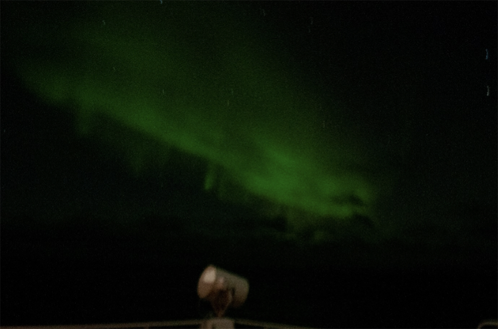
Beautiful Northern Lights in the vicinity of Iceland at the polar circle, around 66 degrees latitude. Image courtesy Mia Schumacher.
By Mia Schumacher
GEOMAR
Given the fact that we are weathering several storms in the shelter of the Faroes, I would like to tell the story of how this little island chain evolved.
When dinosaurs left the planet 60 million years ago, a plateau on the Scotland-Greenland ridge was born. Numerous lava flows from volcanic outbreaks, caused by the divergence of the American and the European continental plates, have created massive solid basalt deposits of up to 30m thickness. Each of those layers bears witness to an eruption, individually separated by thin sheets of tuff – a remainder of the ash rain that is blown out after an outburst.
When the volcanic activity ceased, rainwater rivers started to make their way through and into the rocks, leaving behind sharp ravines and deep dykes which meander all across the plateau – a process, that’s been lasting for centuries. It eventually led to the slow top-down division of the plateau into separate fragments.
Glaciers then took care of the rest and gave the islands their structure as we know it today. Massive ice bodies glided along the ravines and through the canyons. Moraines and pebbles trapped in the ice have ground down the subsoil to an even and plain surface, eventually shaping the characteristic trough valleys.
However, not only fresh water and ice shaped what we today experience as a picturesque island chain – also the powerful North Atlantic water masses – which we became acquainted with very closely in the last couple of days – have not exactly been lazy in the past: High waves and strong winds constantly eroded and washed out the lighter sediment sheets, causing a vast part of the plateau to collapse – and only the Faroes, Iceland, and the Hebrides survived.
Due to their young age (yes, 60 million years is just a flick of the eyelid in our planet’s past!), erosion on the Faroes is not yet far advanced. It is for this reason that the bluff outlines are so typical and unique, having evolved giant, extremely sharp edged and almost perfect vertical walls over time. Depending on literature, Faroes’ cliffs count towards the highest of the world.
Erosion is not only the cause for the size of the walls, it is also the reason why there lives such an exceptional biodiversity. A vast number of bird species built their nests into the tiny holes of the steep walls. They form when, over time, water and fierce winds wash away unstable parts of the cliff. The winter storms can be so strong, that the spray of the waves reaches up to 50m.
All images below by Mia Schumacher, GEOMAR.
Today, there is no active volcanism on the Faroes anymore, but in the steep cliff structure the typical shapes of volcanoes are still very clearly seen
Approaching the Faroes: These are the remains of a former crater, partially sunk into the wild ocean.
Those incredibly perfect perpendicular walls are characteristic of volcanic evolved landscape. The sharp edges account for the young age of the islands.
Even when covered in snow, the layering of the massive basalt sheets is still clearly visible.
Sheets of basalt and sedimented ash rain tell stories about past volcanic eruptions. Storms and waves continuously erode the vertical wall, leaving small holes that are populated by a vast number species of birds.
By Mia Schumacher
GEOMAR
Welcome to our cruise blog! Lovely to see you (back) here.
After setting sail yesterday morning, 5 November, we are already heading through rough North Sea weather. I mean, who would have expected something else than stormy and choppy waters at this time of the year in that location? Although, it is still relatively calm compared to what weather we expect to come within the next couple of days… A little spoiler here: Our original plans are blown with the wind for the time being – and are replaced with weathering the storm by hiding in the wind shelter behind the Faroe Islands.
Therefore, at this stage we do not have a lot of scientific stuff to talk about (yet). What we do talk about though is the UN Ocean Decade – a massive ambitious initiative designed over a ten-year timeframe and dedicated to our ocean. The aim is to wrap up all the different social, economic, industrial, political, and scientific interests concerning their – partly very divergent – demands on the ocean and bring all those parties together on one table. The overarching goal is a resilient and healthy ocean by 2030 – and until then join forces to find ways and figure out how to reach this. This can be practical approaches e.g. ‘invent tools to stop plastic discharge from estuaries into the oceans’ or more general foci on communication strategies about how to bring people together to talk. We are very proud that our IceDivA2 cruise is part of the UN Ocean Decade programme in the frame of a satellite event – a two-hour time slot showcasing our on board activities for a clean ocean. Just as a heads up: We will be hosting a live stream which enables everyone interested to come aboard and unite from all over the world. So – save the date and join us live on the 18 November between 5 – 7 pm CET! More information and a link to the livestream will follow in a later blog entry.
In the meantime, we prepare – both for the upcoming weather and the livestream – all the gear, labs, and instruments we brought with us. Amongst these is benthic gear such as the epibenthic sledge, multi – and box corers, and also water column sampling instruments such as plankton nets and water sampling devices. To dive down into the world of the ocean floor, we use ship-borne multibeam echo sounding as well as our deep-sea towed camera system which provides us with beautiful footage. Let’s see what the future brings! Stay tuned to keep up with our journey into the North Atlantic!
There remains nothing to say. The North Sea lets us know who she is and what power she bares. And this is by far not all she has!
This shot and the one to the left have been taken from the bridge, 18 meters above sea level.
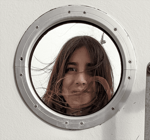
What looks like a washing machine window is in fact a capture out of a cabin porthole - usually with a view on the horizon. Well, not in these conditions!


