We’re in the middle of our transit to the Reykjanes Ridge region south of Iceland. This is a good time to talk about the bigger picture, why we chose Iceland as a research area and what it’s all about!
Iceland sits right on the northern Mid-Atlantic ridge, where the Eurasian and the North American plates are drifting apart. It is still active, meaning that the seafloor is spreading at the mid-ocean fracture zone and new crustal material is being produced from the uprising magma. All of these plate tectonic processes involve volcanic activity and the formation of hydrothermal fields, above as well as below the sea surface. Particularly in the case of the latter, the volcanic geology attracts numerous species that make up the delicate biodiversity of the North Atlantic benthos. Hydrothermal vent areas, where hot water escapes the earth’s mantle and meets the cold deep-sea waters, can be home to unique fauna that is rarely found anywhere else. Also, the topography on and around Iceland is exceptional: the island is surrounded by the deep Denmark strait channel on its western continental shelf, triggering a massive submarine waterfall about 600m high. On the island’s south-east side, ridge and sea mound structures prevail and cause a complex pattern of different water flows, from among which one of the most important is the north Atlantic overflow – a very strong and deep water current. The Norwegian Basin north of Iceland is the deep, ‘calm’ abyssal plain. Hence in terms of geomorphology, biodiversity and oceanography, the North Atlantic is a natural laboratory which holds the key to so much information about the formation and origin of life and our planet.
There have been numerous cruises to this area before and with IceAGE3. We are trying our best to fill data gaps and build upon a database of samples and models that has been existing for many years – aiming to find explanations for the distribution and population variations of species (and what could be a better indicator for that than isopods?), how and where they travel and how they react to a changing climate, and human impacts. So far it has been discovered that isopods wander from Norway to Iceland and then head down the Reykjanes Ridge – the part of the Mid-Atlantic ridge located just south of Iceland and is basically the extension of the faults on the island. This is where we are steaming to now, ETA tomorrow morning. We will spend the next three days in this area searching for hydrothermal vents and hunting gas bubbles that are emitted from their chimneys. Using hydroacoustics and imagery from ROV dives, we hope to discover more of this mystical under water world beauty.

Before beginning on the long transit to the ‘southern’ part of our voyage, we spend another two days sitting on Iceland’s continental shelf and doing ROV dives through the beautiful coral reef landscapes. Sadly, evidence of fishing pressures on these beautiful structures is visible. Corals need centuries to reach maturity, and on seafloor devastated by fishing activity they will probably never be able to grow again. Even in the bathymetry data we are able to see the footprint left behind by (most probably) the nephrops trawls – a fishing instrument used to skim over the seabed to catch lobster and langoustines. The positive side of this story is that the reefs were destroyed before people knew about their existence, and the reefs in the Lonsdjùp area were placed under protection in 2011. We aim to create more and more marine protected areas in the future.
Luckily, there are still some very vivid reefs and ocean inhabitants around us, as we can tell from the ROV dives. Thanks to incredibly good weather conditions – warm (well, as warm as it gets at 63° N, but t-shirt weather works!), sunny and calm sea – we can dive nearly every day.
Speaking of which – it is a unique experience to see R/V Sonne so far up north, as its usual area of operation is the Pacific and Indian Ocean. Although coronavirus is limiting a lot of travel, we now at least have the opportunity to do our research in the colder waters. Seeing this vessel in front of Iceland’s snow-covered summits is a very rare scene that we are able to enjoy, thanks to the gorgeous crew who took us on a Zodiac tour around our mother ship. Tomorrow it’s time to leave the continental shelf area and head for a region south of Iceland on the mid Atlantic ridge, where we hope to find hydrothermal vents.


We spend this day a little further north-east on the continental shelf sampling for all we are worth! In total, we have 20 stations (deployment of four CTDs, four box corers, four multi-corers, four epi-benthos sledges, and multibeam in between!) to be finished today before tonight’s transit back to the panoramic view on Iceland – a tough schedule but the weather is unbelievably nice, with sun shining and a dead calm sea! The day started again with another (or the same?) big school of pilot whales hanging around and watching us – life could be worse! Enjoy the photo show!


Yesterday morning we arrived on the continental shelf of Iceland – and a stunning panorama of glaciers, volcanoes and the rough cliffs of that beautiful island was awaiting us, immersed in bright sunlight. Not only was the view above the ocean surface great, but the ROV dive along the seafloor was once again a fascinating journey through all sorts of corals, lots of fish, fields of sponges, barnacles, and many more interesting beasties! There is a special interest in coral reefs as they are very important for both the food web and habitat complexity. Whilst to the untrained eye there is hardly any life on the sedimented seafloor, once solid substrate appears, life flourishes and complex ecosystems develop for all to see. Coral reefs can be vast in their extent and aid in the diversity of live in the surrounding area the improving habitat heterogeneity. Hence preserving coral reefs is a major concern for nature conservation and also for the fishing industry. Within the iAtlantic project, predicting such reef structures from bathymetry and its derivatives (slope, backscatter etc.) using spatial distribution models is an inherent part of our work. Depending on their accuracy, those models can be used to create habitat maps and locate coral reefs without having to conduct costly and time consuming (although really, really nice!) ROV dives. Also, highly accurate models can reduce the need for in-situ sampling, which is carried out more or less blind, though some ground truthing is of course inevitable to feed the models and to examine their performance. Laurence de Clippele from University of Edinburgh, UK, is working in the iAtlantic project and she is the one creating such models. She has provided us with her data that show maps of potential coral reef locations. We are now trying to verify those models by diving in target areas indicated by the models to confirm whether it is a coral reef or not.
As those vulnerable reef structures can become a victim of trawl net fishing, we hope to put those sophisticated complex organisms under protection against human impacts.


We have spent three spectacular days in a row in the deep! Today and yesterday, we dived down to the beginning of Aegir Ridge fracture zone with our ROV and witnessed, once again, the most stunning impressions of life on the unknown mysterious seafloor. Nothing can describe what we look at better than images and that’s why I will stop writing soon and let the photos speak! Just one more important thing to mention at this point: Yesterday (4.7.2020) was the 300th dive for the ROV Kiel 6000. This is a good opportunity to congratulate the excellent ROV team and thank them for making these unforgettable dives possible! It’s an honour to be part of this fantastic journey with such remarkable imagery of the flourishing life below the water surface.


Day 13: Friday 3 July 2020
A day full of mapping! We have put behind us 20 hours of transit to our next survey area, located just east off the Icelandic continental shelf, at the very beginning of Aegir Ridge. That’s where we expect to find reefs of cold water corals – the ‘Lophelia’. Corals are, as any other hard substrate on the seafloor, the solid base to most marine life. They build vast reef areas and are home to the most delicate biodiversity. Although being totally different in appearance and motion, medusae (or jellyfish) and corals have something in common: both animals belong to the group Cnidaria. They use nettles to capture their prey and to defend themselves against predators. However, unlike jellyfish, the corals’ harpoon-like nettles sit in cnidocytes and can be expelled whenever something is passing by.

Depending on the local water depth, corals can be seen in the multibeam bathymetry. Hence doing a careful map survey in advance to a ROV dive can save a lot of time as the location of the dive and where to take samples can be decided a lot more precisely. However, it’s also important to know the local water depth, which can usually be derived sufficiently enough from satellite altimetry (down to a resolution of about 1km, the seafloor topography can very roughly be obtained from satellite gravity measurement). In this special case however, at the beginning of Aegir Ridge, the difference in depth between the altimetry model and the true multibeam bathymetry was up to 1000m – and that makes a huge difference if the water depth is between 700 and 2600m!
Another day with a successful ROV dive finished. We observed various different species and traces – from the most peculiar feeding trails made by Holothurians (sea cucumbers), tracks from trawling nets, piled up sediment with a wormhole on top (which resembles a mini volcano), small red shrimps drifting slowly through the water, and lovely sponges in the middle of the deep-sea desert that are blooming with life and give home to a lot of small creatures. A lot of the species are known already and can be identified in real time by the deep-sea life experts on land who are watching the video stream and tune in on board via live chat.


All of a sudden during our journey along the seafloor, the environment has changed and we are facing a massive slope which is quite steep. This is probably the remnant of giant debris flows of former times and moving plates, when the Aegir Ridge was still tectonically active. A consolidated sulphite substrate bottom is home to various species of crustaceans, sponges and also polychaetes – little worms that live in/on the benthos. Surprisingly, not one single fish was around although this region is known to be a popular fishing area. Just before the ROV ascended back to the ship, we found a plastic tube sticking in the seafloor. It was already forming a home for an anemone and decapods – a literally living example of the fate of litter on the deep-sea floor. Once it sinks, it rapidly becomes a vivid habitat to all sorts of animals. However, it also starts to decay, falling apart into smaller and smaller pieces until it is broken down to sub-millimetre sized pieces. These are taken up by the tiniest animals in the food chain, those are eaten by the next bigger ones and so on and so forth, until it is everywhere, in every body. This is not only theory, let’s face it – our biologists on board have already found microplastic in the sediment from 3000m water depth when examining the MUC, EBS and box core samples. It is already all around us and it’s probably impossible to ever totally free our oceans from microplastic again, but we should strive to stop putting more in.

As expected (and also known to be typical in the North Atlantic), the bad weather hit us over the last two days. Although perhaps ‘bad’ is not a good word as rocking hard in big waves is some sort of a thrilling experience that some of us really enjoyed. Others had to struggle with serious sea sickness and breathed a sigh of relief when the sea calmed down again.
Working on the main deck was becoming more and more impossible, and when the wire of the MUC was becoming tricky to handle, chief scientist and captain decided to cancel all in situ operations (box corer, CTD, plankton net, EBS, MUC). The only activity that is usually feasible in such conditions is mapping the seafloor and that is what we tried to do, heading north against the wind and waves to stabilise our course. However, at around 2 a.m., the ship motion became so severe that even mapping was not possible. The bridge ordered to stop the survey and do ‘weathering’ instead: Trying to remain in place, keep the roll and pitch movement low and wait until the storm is over. Luckily, this happened to be right on the polar circle! So we got the opportunity to spend one night on the border to where the sun never sets in summer and never rises in winter time. Amazing! Although, very honestly, I couldn’t have told we’re on the polar circle- it didn’t look different, neither the water, nor the seafloor. Nevertheless, it is exciting to be up north at 66° 33’ N with daylight all around the clock!
When the wave height decreased in the next morning, we continued our daily business and started doing a CTD profile. One interesting fact about our study area in the Norwegian Basin is that two major water current systems join up here: the North Atlantic current carrying warm (well, 6°C) salty Gulf Stream water to the Barents Sea at depths around 50-100m, and the Norwegian Current, which transports colder (4°C) and fresher waters – mainly from the North and Baltic Seas – southwards. Although these differences in temperature and salinity may not seem big (both 6 and 4°C being very cold) they have significant effects on the water current system. Even those small variations result in density gradients which are, along with wind, one of the main drivers for keeping oceanic water masses flowing. This is essential for the transport and distribution of nutrients and hence the basis for all marine life. Furthermore, without functioning ocean currents, there would hardly be any existence possible as they act as our planet’s ‘air conditioning’. Thus, big waves are not only beautiful to look at – without them, we wouldn’t be here on this earth!

Back in Germany, summer time is reaching peak temperatures of at least 30° (even in Kiel!), but here we stay with a chilly 9°C and wind gusts of around 7-8bft. The dream of sunbathing on the deck soon dissolved into nothing when we arrived at 65°N. As waves are getting higher, moving around on the ship is becoming cumbersome and we expect the sea to become even heavier in the next couple of days…thus people may wonder why we are doing this, missing out on beautiful summer time and going in the cold north instead to see only water for five weeks and struggle with sea sickness? I can tell you – it’s so worth it. It is an experience that not many people will ever get the chance to experience: seeing what is there in 3000 m deep in the ocean on the video screen during the ROV dives, touching the seafloor sediment that’s being collected with the MUC or box corer, exploring the sea floor morphology and discovering new structures, bearing witness to the most peculiar deep-sea fauna, hearing the waves smash against the portholes in the cabins … or just sitting in front of the windows trying to spot some whales. And all of this is happening in endless daylight (because the sun doesn’t want to set in these latitudes in this season). It’s an experience nobody will ever forget.
And speaking of seafloor bathymetry, over the last few days we’ve been mapping Aegir Ridge – a former mid-ocean ridge that was active during early Eocene (about 50 million years ago). The associated seafloor spreading processes were one of the main drivers for the formation of the Norwegian Basin. The extinction of Aegir ridge is placed around 25 million years ago in the late Oligocene, meaning that there is no active tectonic movement now, but the typical ridge structures can still be observed in the hydroacoustic data.

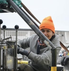
Furthermore, unusual seafloor structures hold unusual species and this is what our biology team on board is discovering! What looks like mud-slinging and sludge silt digging is in fact the extraction of the most valuable ground truth data. From very old ancient sediment, conclusions can be drawn about the development of deep-sea life from ancient past right up to the modern day. It is a lot of work though and getting the mud on board is only the very first step: that’s followed by sieving and washing to get rid of the coarser particles, centrifuging to separate organic from inorganic matter, and then manually picking out the interesting bits to look at through the microscope. The ‘rough’ cleaning procedures are already done on the ship but the time intensive precision work is done back home.

Tina Stein (right) is a technical assistant at Senckenberg am Meer in Wilhelmshaven with a focus on biology and genetics. During the cruise she takes care of the plankton net and its catch. When deploying the plankton net, she is the responsible person for the work on deck. It has been her wish to go on a research vessel ever since she started her apprenticeship and now she is here!
A really successful ROV day with most beautiful imagery from the deep-sea floor, as well as samples that will help understanding the biodiversity across the north Atlantic abyssal plain, came to an end last night.

It was followed by a busy night deploying “Ursula”, the newly christened EBS (Epi-Benthos-Sledge), which is dragged over the seafloor to collect the upper sediment layer. Then came the box corer, which has a big shovel that digs into one spot of the seafloor rather than shaving off a large area. The final instrument of the coring class is the MUC, multicorer, that pushes cylindrical shaped tubes of about 10cm in diameter and 50cm in length into the seafloor. This is a good opportunity to introduce some more of our scientists to you – namely those who are in charge of these devices!
Stefanie Kaiser is looking after Ursula, the EBS. She is from Łódź University in Poland and, despite being German, representing a whole foreign research team who couldn’t join the cruise themselves because of Coronavirus travel restrictions. She enjoys working with isopods, not only because they are fundamental food chain fellows, but also because they are ancient creatures and therefore suitable for long term studies as they can tell stories from the far past but also from recent changes. To understand biodiversity and its transformation in a changing climate, isopods and amphipods are essential indicator species.
Anne Nina Loerz (CeNak, University of Hamburg) loves amphipods. Wherever she is, these small little crustaceans show up. Anne has been studying them for ages and, similar to isopods, they form the basis of the food web. They are key players in all marine environments down to the deepest trenches- and certainly in habitats where we will take samples during IceAGE3. Moreover, they also act as abyssal police(speci)men and deep-sea garbage collectors, i.e. cleaning up carcasses of other dead marine inhabitants. Anne promised to discover new species during this cruise, so stay tuned!
Nancy Mercado Salas from CeNak is taking care of the MUC (multicorer) and the meiofauna that is kept in its tubes after retrieval. She particularly likes ‘digging in the mud’ and the exciting fact is that at least 80% of the species are still unknown – meaning that in every MUC, there is something new to discover! In the remaining 20% that are known, Nancy’s favourite animals, the copepods (another type of little crustacean), make up one of the largest group of all meiofauna in the benthos. As with the other crustaceans, they serve to prove the theory on biodiversity transition that is connected to ocean acidification and a rise in temperature.
© 2024 iAtlantic. All rights reserved.
This project received funding from the European Union’s Horizon 2020 research and innovation programme under grant agreement No 818123 (iAtlantic). This output reflects only the author’s view and the European Union cannot be held responsible for any use that may be made of the information contained therein.