High resolution 3D point clouds and orthomosaics:
Filling the gaps in deep-sea spatial ecology
Deep under the ocean surface, the seafloor can be as rugged as the most scenic landscapes on Earth like the Grand Canyon or the Alpine divide. In these rugged seascapes, environmental conditions may change dramatically over distances of a few kilometres to just a few meters, thus creating mosaics of habitats at different spatial scales.
Working at a range of scales
In the dark deep sea, the challenge is to map and characterise these habitats at all relevant spatial scales, from the largest to the smallest. For the largest, technological developments in acoustic methods and Autonomous Underwater Vehicles (AUVs) now allow large areas to be mapped at a 1-metre resolution. For the smallest scales, high resolution cameras on Remotely Operated Vehicles (ROVs) reveal the finest details of interactions among species and with their environment. For intermediate scales, where we want a larger view of the landscape but with high resolution a combination of acoustic methods implemented from an ROV and continuous developments in computer vision, namely here the Structure from Motion technology (SfM), are yielding exciting results. SfM uses a large number of overlapping images to reconstruct a scene in three dimensions. Applied to the seafloor, this technique provides 3D models of complex habitats with a resolution lower than a centimetre.
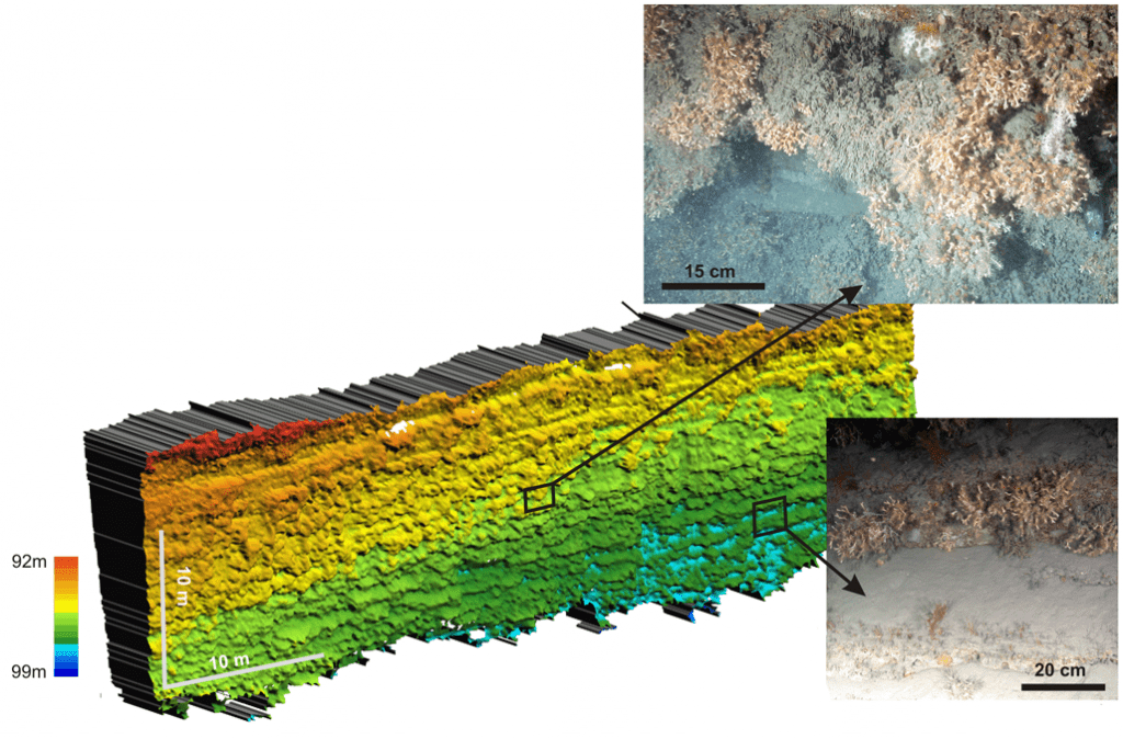
Within iAtlantic, these new techniques have been used to get a better understanding of the distribution of habitats such as cold-water corals in submarine canyons or hydrothermal vent fauna on a mid-oceanic ridge. In a hydrothermal field off the Azores, a vent chimney has been fully reconstructed in 3D using SfM (see Figure 1, right). Over the years, the technique demonstrates an unexpected stability in the distribution of vent assemblages, which questions the dynamics of hydrothermal vent ecosystems. In submarine canyons, vertical walls have been mapped with a multibeam echosounder mounted on the face of an ROV. The resolution achieved allows individual coral colonies to be distinguished (Figure 2, below). These vertical walls attracted interest of iAtlantic scientists all across the Atlantic, from off Ireland and France to the Azores and Greenland. 3D reconstructions of these walls show how fine scale heterogeneities in the topography and orientation of the walls may influence the distribution of species (see Figure 3, below). These new tools pave the way towards a better view and better understanding of deep seascapes but also pose new challenges. The volume of data is huge. In addition to requiring large computing power, data processing still involves cumbersome image annotations. Within iAtlantic, models based on Artificial Intelligence (AI) have been tested to turn the information contained in images and 3D models into meaningful habitat descriptors.


Beyond scientific research
Beyond their scientific interest, 3D models can be used by a number of end-users to explore a 3D scene with no limitations in light or limited field of view. Digital tools such as 3D videos or Virtual Reality headsets can help to raise awareness and literacy regarding deep-water habitats, as illustrated by the photos below.


Want to know more?
The full D2.3 report will be available once the review process is complete
iAtlantic Deliverable 2.3: High resolution 3D point clouds and orthomosaics: Filling in the missing space in deep-sea spatial ecology. Report by Menot L., Huvenne, V.A.I., Matabos M., Butschek F., Carreiro-Silva M., de Oliveira L.M.C., Dominguez-Carrió C., Fabri M.-C., Ferrera M., Legendre P., Lim A., Marcillat M., Morato T., Perrois G., Price D., Sarrazin J., Schoening T., Van Audenhaege L., Wheeler A. J. & Olu K. January 2023.
© 2024 iAtlantic. All rights reserved.

This project received funding from the European Union’s Horizon 2020 research and innovation programme under grant agreement No 818123 (iAtlantic). This output reflects only the author’s view and the European Union cannot be held responsible for any use that may be made of the information contained therein.