Models of VME taxa and functional traits distribution:
Maps demonstrating the outcomes of Atlantic-wide VME taxa and functional traits distribution modelling
The deep ocean plays an important role in climate regulation by absorbing and storing heat and carbon dioxide. However, these regulating services have consequences for the health of the ocean including warming, acidification, and deoxygenation of deep waters, leading to decrease in food availability at the seafloor. These projected changes may severely affect the distribution of deep-sea fauna, including species that underpin Vulnerable Marine Ecosystems (VMEs) as well as commercially important species, thereby compromising key ecosystem services.
Modelling the spatial distribution of marine species and their suitable habitats has become a common practice in recent years. These modelling approaches use information about the environmental conditions that underlie species occurrence to model the species ecological niche and to make predictions about their potential spatial distributions. A key expected output of the iAtlantic project is the production of maps of the distribution of key Atlantic marine species along with models predicting the impacts of climate change on Atlantic ecosystems. These ocean basin-scale predictions were developed to assess the stability of Atlantic ecosystems to climate changes and define requirements for sustainable management and inform policy developments that ensure and encourage a sustainable Blue Economy.
Within iAtlantic, we developed habitat suitability models for deep-water commercially harvested fish and shrimp, vulnerable deep-water sharks, several cold-water corals, seapens, and sea-urchins. The study area considered in this work was defined as the boundaries of the Atlantic Ocean, from 74°N to 60°S and 25.8°E to 98°W. To model the habitat suitability under present-day (1951–2000) conditions and to forecast changes under future (2081–2100) climate projections we employed three widely-used algorithms: (1) the maximum entropy model (Maxent), Generalised Additive Models (GAMs) and Random Forest machine learning algorithms (RF). The modelling approaches considered several environmental predictors of the present-day (1951-2000) and future (2081-2100) under different Representative Concentration Pathway (RCP) scenarios as part of the Coupled Model Inter-comparison Project Phase 5 (CMIP5; RCP 2.6, RCP 4.5 and RCP 8.5 scenarios).
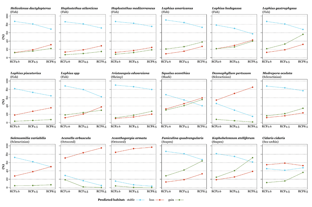
The potential suitable habitat of most species spanned a wide geographic range, with higher suitable index on the continental shelf and slope of the wide Atlantic Ocean, mostly at higher latitudes of both hemispheres. It should be noted that the predicted habitat for cold-water corals was high in ocean ridges, isolated seamounts, and around oceanic islands. Patterns in suitable habitat under future climate conditions differed markedly for the different species and climate projection scenarios. In general, most taxa showed a decrease in the suitable habitat under future environmental conditions. The decrease is more pronounced under higher emissions scenarios. For those taxa with a decreasing trend, the average net habitat loss changed from 22.3% for the RCP 2.6 to 33.9% under the RCP 8.5 scenario. The models also predicted differences in the refugia area, lower under high emissions scenarios, varying in average from 72.7% of the present-day habitat under RCP 2.6 to 54.8% of the under the RCP 8.5 scenario. The RCP 4.6 climate projection scenario produced, in general, intermediate projections. In term of shifts in median latitudinal distributions, the models projected, in general, a shift towards higher latitudes of both hemispheres for deep-sea fish, sharks, shrimps, and seapens, a shift towards lower latitudes for most cold-water corals, and a marked latitudinal compression for the sea-urchin. These trends are more pronounced under the RCP 8.5 scenario when compared to RCP 4.5 or RCP 2.6.
HSM predictions and projections come with a large number of limitations and uncertainties frequently discussed in the literature. In brief, this includes limitations from the quantity, quality, and spatial coverage of occurrence data, availability of absence records, as well as some uncertainty in deep-sea species identification (mostly for cold-water corals); limitation from the quality and spatial resolution of terrain and environmental data; limitation inherent from the modelling approaches; mismatches in spatial or temporal scales; uncertainties related to future climate scenarios; uncertainties regarding potential acclimation and adaptation of deep-sea species to changes in environmental conditions, along with interspecific genetic variability and potential for local adaptation; among many others. Despite all these caveats, recent studies suggest that HSM are useful identifying undetected populations or to exclude locations where environmental conditions are unsuitable to support even minimally viable populations. Therefore, if used with caution habitat suitability models can become valuable tools to inform environmental management and conservation policy and provide a basis for taking climate change into consideration.

Want to know more?
Download the full report
iAtlantic Deliverable 2.2: Models of VME taxa and functional traits distribution: Maps demonstrating the outcomes of Atlantic-wide VME taxa and functional traits distribution modelling. Report by Morato, T. et al. (February 2023) (PDF, 9.7MB)
Banner image courtesy NOAA Stepping Stones expedition 2021.
© 2024 iAtlantic. All rights reserved.

This project received funding from the European Union’s Horizon 2020 research and innovation programme under grant agreement No 818123 (iAtlantic). This output reflects only the author’s view and the European Union cannot be held responsible for any use that may be made of the information contained therein.